|
|
||||||
Area units: Data units:
|
 |
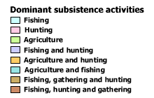
Dominant subsistence activities |
 |
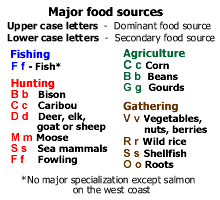
Major food sources |
| Checkbox controls the visibility of the subsistence activities layer. Click on the label icon |
|
 |
This layer shows modern geography (current provincial and territorial boundaries, as well as selected cities), and is available for reference. |
| Active layer: Subsistence activities is always the active layer. This is the active layer. Use the tools below to get data about the areas in this layer. | |
Identify: Click on the Identify tool, then click on the map on one of the areas, to pop up a box showing the dominant subsistence activity. |
|
Table: Click on the Table tool, then click or drag a rectangle on the map across one or more area , to select areas and pop up a table showing information about them. See Table Fields below. |
| Dominant activities | Dominant activities for area with major food sources in parentheses. |
| Secondary activities | Secondary activities for area with major food sources in parentheses. |
| These maps are based on secondary sources with extensive adjustments according to earliest European observations. |